

Project Westhinder started life early in 2017. During the yearly survey of what the members like and dislike within GUE-BE, it became clear that there was a lot of demand for project-related diving. GUE-BE and its members had been part of various projects in the past, like Project Baseline in Ekeren and the Berghse Diepsluis, the European NETLAKE project, net removal on wrecks in the North Sea, and others.
With some of those projects coming to an end, it was time for something new. A few members had been part of GUE’s Documentation Contest in Croatia a while back, where several teams competed to document their assigned wreck in the best way possible. They found that diving the same wreck multiple times in succession adds an element to the dive: once you start knowing the overall layout of the wreck, you start paying more attention to interesting details. Combining these dives with conducting research on the surface and distilling all that information into a website dedicated to the wreck and its crew turned out to be a rewarding and fun thing to do.
If we could do this in Croatia, why wouldn’t we be able to do this in our own North Sea?
We were not planning to continue with the net removal project on the North Sea in 2017, which gave us the opportunity to use the scheduled North Sea dives for this new project.
Amongst our members we also have divers with a variety of skills useful for surveying and documenting wrecks, and a willingness to learn where we were still lacking knowledge.
There was of course one problem, and that was deciding which wreck to pick. Everyone has their favourite wreck on the North Sea, but in the end we settled on one that might not be everyone’s first choice: the Westhinder.
We had several reasons for picking the Westhinder. From a practical point of view, at maximum 30 metres, it is not the deepest wreck, which gave us a decent amount of bottom time per dive. Additionally, it is relatively small, which makes it easier to survey the whole wreck.
From a historical point of view, it is one of the first wrecks to receive heritage status, and is a remnant of a time where light ships were used to warn shipping for dangers – the Westhinder sandbank in this case – and for scientific measurements like wind speed, currents, water salinity, and more, tasks that have since been taken over by automated light buoys.
The project was introduced to all members during a kick off day, where it was received very positively, with a lot of people volunteering to take on key roles in the project.
In the video below, one of the project leaders talks us through how we organised ourselves in more detail.
Once the choice to run a project on the Westhinder wreck was made, we soon figured out that we should make a mini documentary.
There already was a lot of information to be found about the Westhinder, so we wanted the documentary to focus on the project itself.
This was a bit of a plunge in the dark, as we didn’t know how the different goals of the project would turn out, and hence we were not sure what we would be able to show in the documentary.
Not being sure where exactly we were going with the scenario yet, we just started to capture footage of the other teams during their activities. We figured that, as the project progressed, we should be able to use some of the material in the end result.
We wanted to capture as much underwater footage as possible, as that would obviously be vital to the documentary, because the conditions on the North Sea can change quite quickly and opportunities to film might be limited, and also because in general, you only use a fraction of your footage.
Since we only had a limited number of trips to the wreck, we trained a number of the project members in handling video lights under water. A good balance between the light diver and the camera diver is essential to get good shots, and practice makes perfect, so after each trip we reviewed the footage together with the camera and light divers, and provided feedback.
This improved cooperation and coordination in the video teams, and allowed us to start working with scenarios, and to look for particular shots that we were still lacking. These scenarios were based on story boards, which highlighted the movement of the lights and camera relative to the wreck. This helps the teams get a better understanding of what they need to do in the water, and greatly improves efficiency while filming.
Of course we also needed shots above water – at the end of the day most of the time on the project was spent on dry land. Think of shots of Ostend, where the Westhinder set sail, of bad weather, of preparations on the boat right before jumping in, and of team meetings.
As we gathered the results, not just of the video teams but also photography and 3D, we tried to integrate most of it into the documentary. Both the images as the audio work towards a climax showing a rendering of the detailed 3D model of the complete wreck.
Audio can be a difficult matter, as you quickly end up in a debate of tastes. Both for voice actors and for the background music, different people will have different preferences. We settled on choices that the whole project team could stand behind.
A lot of time was spent, by a lot of people, on producing the end result below. We hope you enjoy watching it as much as we have enjoyed making it!
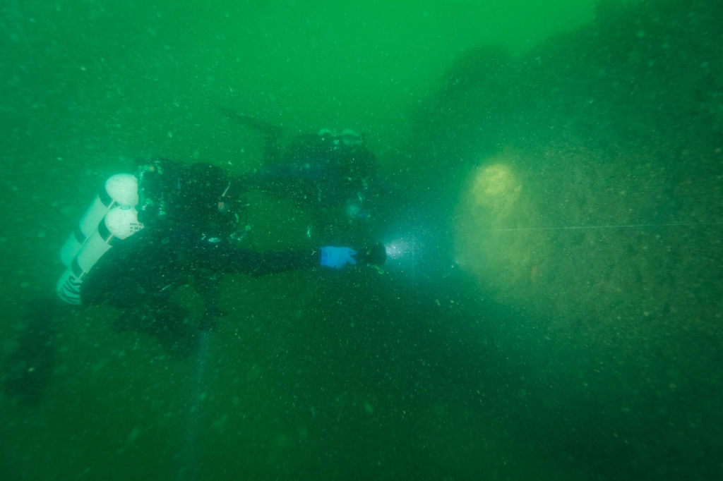
3D modelling wrecks on the North Sea is no easy task. To get a good model of any object, you need a lot of clear, sharp, well-lit images from all angles. There are quite a few factors that make this a challenge on the North Sea.
First of all, there is not enough light at 30 meters. This is a problem that is shared with underwater photo- and videography, and the solution is also the same – bring your own light. We used both videolights on the camera and an additional light diver to ensure there was sufficient illumination for the 3D images.
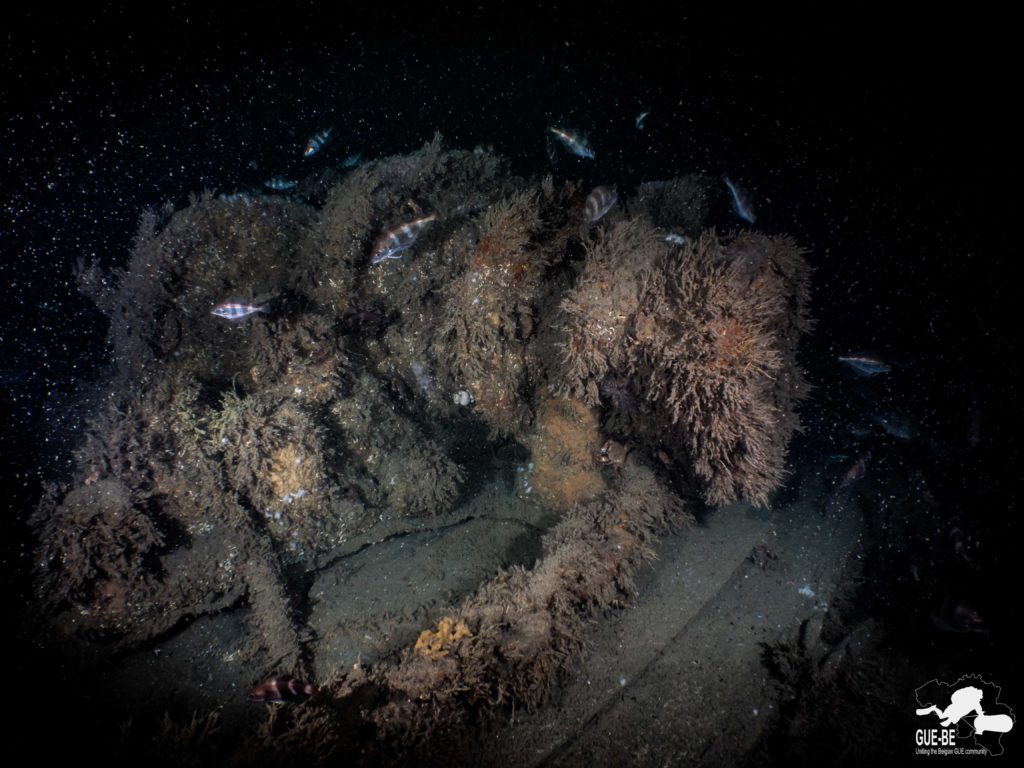
A second thing is that for a computer to be able to construct a 3D model out of a set of 2D images, you need the object to remain still between images. Imagine how difficult it would be to make a 3D model of a tree swaying in the wind, or a person walking – the object would not appear the same in any of the images. Of course, the Westhinder wreck sits on the bottom of the North Sea and does not move much itself, but the vegetation that grows on it does sway in the current.
Moreover, the various dive days were months apart, starting beginning of spring and ending in autumn. The vegetation varies drastically. In spring the full wreck was covered leaving almost no clearly visible parts. While in autumn some of the remaining wooden deck planks were clearly visible. These variations make it difficult to combine video footage from the different days.
3D team working in low visibility
An additional issue is the fact that the waters in the North Sea are not exactly crystal clear. The visibility can be quite low, due to all the sediment that is suspended in the water, and this makes getting clear images more difficult. Compare it to taking a picture of a large object through a thick fog. If you are far away, you can get the vague outlines of the object, but that is useless for photogrammetry because you need crisp, clear images. The only way to get that in those conditions, is to get closer. The problem now is that you can’t capture the whole object in one image anymore, which you can fix by taking multiple images from the different bits of the object, and then stitching those images together. Each consecutive image needs at least 70 to 80% overlap with the previous one to allow stitching.
This brings us to the next challenge: the size of the wreck. At 33 meters length, the Westhinder is not a massive wreck, but if each of your images only covers about 0.5 square meter, and you need to get very close to the wreck to get those images, you can imagine that it becomes very difficult to make sure that you have covered every bit of the wreck. In the next clip, our 3D team lead explains how we tackled this.
Despite the difficulties mentioned above, we decided to try the photogrammetry technique, focusing on a small and recognisable object first: the winch. Many weaker parts of the wreck have collapsed or disappeared after more than 100 years in salt water. The winch, being an almost solid metal part remains prominent on the deck.
The winch
In the model above, the result of that work has been layered over a white model – this is our interpretation of what the winch would have looked like if it had not spent the last 100 years at the bottom of the North Sea.
The success of the modelling of the winch gave us the confidence that we could map the entire wreck. In the subsequent dives, the model grew, section by section, finally culminating in the model that we are proud to present here:
Tip: depending on your computer, the models might show in low quality by default. To change this, press the settings wheel, select ‘Textures’, and tick ‘HD’. It might take a little while to load the HD texture, but it’s worth the wait!
In the Belgian North Sea alone there are more than 200 wrecks, many of them from the first and second world wars. Since 2014, 8 wrecks have been given the status of national heritage. They are not to be lifted, but will remain where they are with protective measures. Although they are still accessible to divers, there is a prohibition on activities that could damage the wreck, like anchoring, fishing and dredging.
The Westhinder II, sunk in 1912, is one of these 8 wrecks. The Westhinder was important to shipping at that time because of the tasks it fulfilled – it marked the safe route by indicating the position of the Westhinder sandbank. It also functioned as a platform for marine and meteorological research, including measurements of current, wind, salinity and plankton concentration.
Until 1994 (Westhinder VIII), the Belgian lightships were beacons for navigation, constructed specifically to anchor in spots that are dangerous to shipping. Typical risks include submerged rocks, wrecks and sandbanks close to the shipping lanes. Lightships warned approaching vessels of the danger by either a siren or a bell, light, and in more modern times by radio and radar. The clip below is a fragment from the (Flemish) news reporting on the last voyage home for the lightship.
Marine navigation beacons have been in use since the Roman era. Candles on ships, rafts with bonfires, anything would do to warn ships. The first real lightship was the ‘Nore’ in 1731, anchored off the Nore sandbank at the mouth of the River Thames in England. As this idea started to spread, at the start of the 20th century there were 750 lightships operational across the globe, of which there were 87 in British and 3 in Belgian waters.
These ships were strictly speaking not ships – until the early 20th century they did not have engines, and had to be towed to their anchoring spot. A complex schema was developed to be able to tell the light signals from the various lightships and light towers apart. The Westhinder emitted 2 white signals and 1 red signal, with an interval of 30 seconds.
Towards the end of the 20th century, these lightships were being replaced by automated buoys or unmanned lightships.
A typical late 19th century lightship had a crew 9 or 10: the captain, an engineer, a cook, and 6 or 7 seamen. They worked on the ship for a period of 14 days, after which they were relieved by another crew.
Their job consisted of maintaining the ship, the light beacons and the horn, and changing the way the ship was anchored depending on the current. Additionally, they measured air and water temperature, salinity, current and tidal effects, and inspected the concentration of different plankton species. Any passing ships were noted in the ship’s log. Although this may sound like a boring job, working on a lightship was actually a fairly dangerous profession. The Westhinder that sank in 1912, had already been hit 5 times before:
The following clip shows an English lightship around 1910, very similar to the Westhinder that sank in 1912.
Because of their very nature, sandbanks are a big risk to shipping. They often change location, size and depth. They are primarily formed due to a combination of a sandy bottom, shallow water and strong tidal currents. The Goodwin banks near Kent, England are well known – these alone have claimed over 800 ships over a period of 200 years. At the Belgian coast, the Thorthon, Akkaert, Farye and the North-, East and Westhinder sandbanks are most famous. The Westhinder lightship was anchored near the western end of the Westhinder Sandbank, to warn shipping for the dangerously shallow waters and strong currents surrounding them.
During the night of 12 – 13 December 1912, the Westhinder met its demise. A heavy storm on the southern North Sea caused a lot of problems for shipping. The German lighter ‘Minnie’, which was towing the German steamship ‘Ekbatana’ from Vlissingen to England got into trouble near the Westhinder. A curious detail is that the father of the Westhinder’s captain was a pilot and actually was on board the Ekbatana to guide it to England on this fateful trip, but he was put ashore in Blankenberge to save costs.
Without a pilot, accounts indicate that the Ekbatana came too close to the Westhinder. The strong currents gripped the Minnie, breaking the towing cable, and the lighter slammed into the Westhinder. The Westhinder’s captain had the crew haul the anchor to try to get free of the Minnie, but that failed and the Westhinder quickly capsized and sunk with all hands. The Ekbatana stayed to look for survivors, but with the storm still raging, they found none.
The Minnie meanwhile was adrift, and it wasn’t until a couple of days later that it was found and recovered near Vlissingen.


The team would like to thank


GUE-BE – Vereniging zonder winstoogmerk (vzw)
Zetel: Aarschotsestraat 55, 1800 Vilvoorde
Ondernemingsnummer: 0834 483 476
RPR: Rechtbank van Koophandel te Brussel, Britse Tweedelegerlaan 148 te 1190 Vorst
bestuur@gue-be.be
www.gue-be.be